We know that American glaciers are melting, but for the first time research from the University of Washington have been able to show us just how much and just how fast. The news is unsettling and hints that a glacier-less future could be here sooner than we may have thought.
David Shean, a researcher at the University of Washington in Seattle, has developed a new technique to measure glacier thickness that involves using high-resolution satellite images to track elevation changes. Using this tool, Shean was able to track elevation changes in 1,200 glaciers in the U.S.
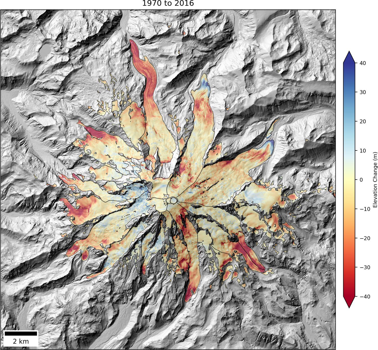
The results have confirmed what many of us have feared: these glaciers are melting quickly. According to a recent statement on the unpublished study, cumulative ice loss at Mount Rainier in Washington measures about 0.7 cubic kilometers since 1970—that's equal to removing a 25-foot thick layer of ice from the entire mountain top.
Related: Iceland: Massive holes caused by violent volcanic eruption open up in glacier
"There are some big changes that have happened, as anyone who's been hiking on Mount Rainier in the last 45 years can attest to," Shean said in a University statement. "For the first time we're able to very precisely quantify exactly how much snow and ice has been lost."
Shean's recent measurements took several years to gather. He started his project in 2012, gathering data on glacier loss in the continental U.S by using the high-resolution satellite imaging system that he originally created to track elevation changes in massive ice sheets in Antarctica and Greenland. The satellite camera takes two photos of the glaciers a few minutes apart and then uses automated software to create a 3-D model of the glacier surface. In his study, Shean provides a tally of 1,200 mountain glaciers in the lower 48 states.
Related: NASA images reveal huge new crack on Greenland's Petermann Glacier
Previously, geologists relied on photographs of glaciers taken from planes and satellites, or used stakes in the snow to measure melting rates. Shean's new method of using high-resolution satellite images allows a never-before-seen look at just how climate change is affecting our country's natural resources, with a resolution accuracy of about one foot.
It's not new information that the glacier is melting. In 2015, a study from the World Glacier Monitoring Service compiled more than 40,000 thickness measurements from glaciers throughout the world. This work revealed that, on average, glaciers are losing about one meter of thickness every year. Other research has estimated that the current glacial loss rate may mean that Mount Everest's glaciers could be completely gone by 2100, CBS News reported.
Shean believes that better understanding of how quickly the glaciers are melting can help us better prepare for the effect this change can have on human life, such as better managing flood risks.
Uncommon Knowledge
Newsweek is committed to challenging conventional wisdom and finding connections in the search for common ground.
Newsweek is committed to challenging conventional wisdom and finding connections in the search for common ground.
About the writer
To read how Newsweek uses AI as a newsroom tool, Click here.