As the California fires continue to rage, including the deadly and large Camp Fire in Butte County, the National Weather Service in Sacramento has warned people living in and around the area about that the smoke is "hazardous."
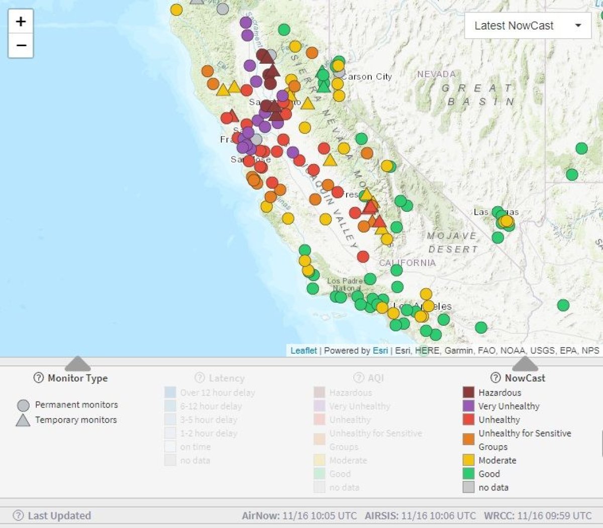
"Air quality continues to be very unhealthy to hazardous across the area. Stay indoors!" tweeted the National Weather Service, along with a map of the area showing just how bad the air quality was in specific areas.
The sun was also blocked out by the smoke. Hannah Chandler-Cooley, a National Weather Service meteorologist in Sacramento, said the sky was now so thick with smoke "it prevents the sunlight from reaching the surface. It prevents surface heating," Bloomberg reported.
Air quality continues to be very unhealthy to hazardous across the area. Stay indoors! #cawx #CampFire pic.twitter.com/dEXJzIVsL5
— NWS Sacramento (@NWSSacramento) November 15, 2018
Smoke from the #CampFire will continue to impact the area. Here's the latest smoke forecast for today through Friday. #cawx pic.twitter.com/EDQwB4F6Tb
— NWS Sacramento (@NWSSacramento) November 15, 2018
Continued reduced visibility this evening with smoke across the area. #cawx pic.twitter.com/cghGAiR3Ze
— NWS Sacramento (@NWSSacramento) November 16, 2018
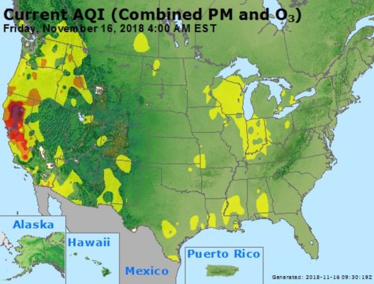
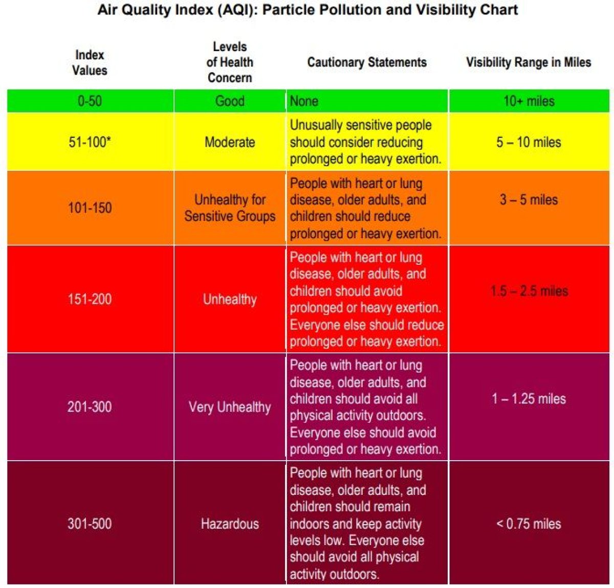
The website for the U.S. government's AirNow map, which measures air quality across the country, shows starkly just how bad the air is in California compared with the rest of the country.
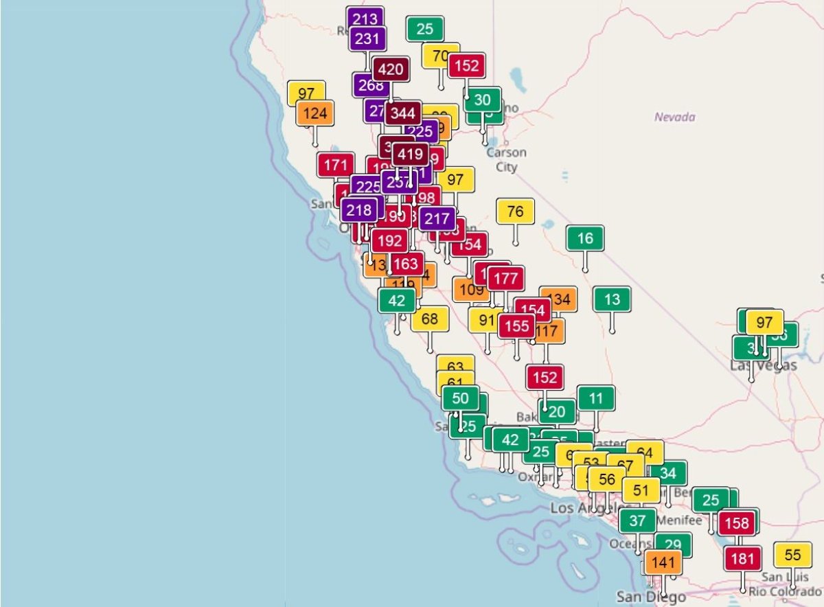
A China-based Air Quality Index monitor using real-time data from more than 100 stations in the California area has a reading of 419 for Sacramento, the worst in all California.
The perfect air quality number is zero, and 300 is the threshold for "hazardous," which means "everyone may experience more serious health effects."
On Wednesday, the Butte County Air Quality Management District and the Butte County Public Health Department issued a joint air quality advisory.
The advisory said unhealthy to very unhealthy conditions are possible through the weekend because the Camp Fire was still active.
It explained that everyone could experience discomfort from the reduction in air quality but people who were young, elderly, pregnant, who smoke or have a respiratory condition were at greater risk for more aggravated symptoms.
Coughing, watery and itchy eyes and difficulty breathing were categorized as aggravated symptoms.
Along with remaining indoors, the joint advisory recommended that all residents keep doors and windows closed as much as possible and wear masks rated N-95 or higher if they must go outside.
The joint advisory also told residents to not use leaf blowers to clean away ash because airborne ash could have negative health consequences.
According to Cal Fire, the Camp Fire spanned 141,000 acres and was currently 40 percent contained. So far, 63 people have died in the Camp Fire and more than 600 more are missing. The fire has also destroyed 9,700 homes.
Full containment was not expected until November 30. More than 5,500 personnel were battling the flames, and mandatory evacuations were in place for the hundreds of thousands of people living in affected areas.
"Firefighters worked throughout the day in all areas of the fire to continue suppression efforts while working to strengthen and improve control lines," Cal Fire said.
"Firefighters implemented both indirect and direct fire attack methods to make progress in containing the fire. Many portions of the fire were burning in steep and rugged terrain where direct fire attack was difficult.
"Established containment lines are holding and firefighters continue to patrol the interior of the fire for hot spots."
Paradise Lost: Inside the Burned-out California Town Destroyed by Deadly Camp Fire
While the Camp Fire was the largest and most deadly, there were multiple other fires burning across California, including the Woolsey Fire outside Los Angeles.
In the Woolsey Fire, three people died and hundreds of homes were destroyed, including those belonging to celebrities such as Miley Cyrus and Gerard Butler. The fire, which spread across 98,362 acres, was 62 percent contained.
Uncommon Knowledge
Newsweek is committed to challenging conventional wisdom and finding connections in the search for common ground.
Newsweek is committed to challenging conventional wisdom and finding connections in the search for common ground.
About the writer
Shane Croucher is a Senior Editor based in London, UK. He oversees the My Turn team. He has previously overseen ... Read more
To read how Newsweek uses AI as a newsroom tool, Click here.