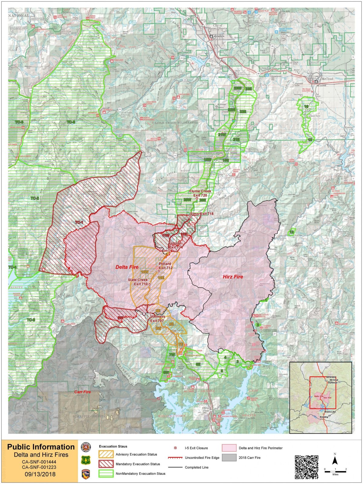
In just over a week, California's Delta Fire has rapidly expanded to become one of the largest fires currently burning in the state. Despite the fire's steady growth, county officials in Shasta County have lifted the mandatory evacuation.
The Delta Fire has burned through 58,427 acres since igniting on September 5, just two miles north of Lakehead, California. The human-caused wildfire was 17 percent contained as of Thursday morning.

Firefighters were able to construct firelines directly along Delta's perimeter on Wednesday due to favorable weather conditions, officials said in a Thursday morning update. Crews were set to focus on securing primary control lines around the fire and to clean up hot spots along the perimeter of the fire.
Authorities noted that Interstate 5, which had been closed due to the raging flames, was re-opened between Redding and Mt. Shasta with limited traffic control.
A Thursday morning incident report noted that all truck restrictions were lifted and added that ramp closures remained in effect at Sims Road and Gibson Road. Flammable vehicles were restricted on the 45-mile stretch and were diverted to the Highway 299 detour, The Sacramento Bee reported.
"Due to re-construction of damaged freeway infrastructure, travelers may be subject to single lane traffic control during daytime hours between Lamoine and Pollard Flat," the incident report said. Motorists were urged to drive with caution and warned that some of the roads off of Interstate 5 remained closed.
The Shasta-Trinity National Forest, including roads and trails around the fire perimeter, were closed, authorities said.
Despite the wildfire's growth, the Shasta County Sheriff's Office lifted the mandatory evacuation order on Wednesday. Residents were allowed to return to their homes, albeit with documentation to verify residency, at Delta Road, Lamoine Road, Delta School Road, Pollard Flat area, Slate Creek Road, Little Slate Creed Road, Eagles Roost Road, Eviesbrood Road and Coyote Pass Road.
The Trinity County Sheriff's Office did not life its mandatory evacuation notice. The mandatory evacuation notice remained under effect for residents living in East Fork Road to Ramshorn Road east to the Shasta-Trinity county line. Residents living in East Fork/East Side Road junction west to Highway 3 northward to Ramshorn Road remained under an evacuation advisory.
Residents of Dunsmuir, in Siskiyou County, remained under an evacuation warning.
More than 3,000 fire personnel were assigned to work the Delta Fire.
Uncommon Knowledge
Newsweek is committed to challenging conventional wisdom and finding connections in the search for common ground.
Newsweek is committed to challenging conventional wisdom and finding connections in the search for common ground.
About the writer
Nicole Rojas is a Breaking News Reporter for Newsweek. Nicole previously worked at International Business Times UK, where she covered breaking ... Read more
To read how Newsweek uses AI as a newsroom tool, Click here.