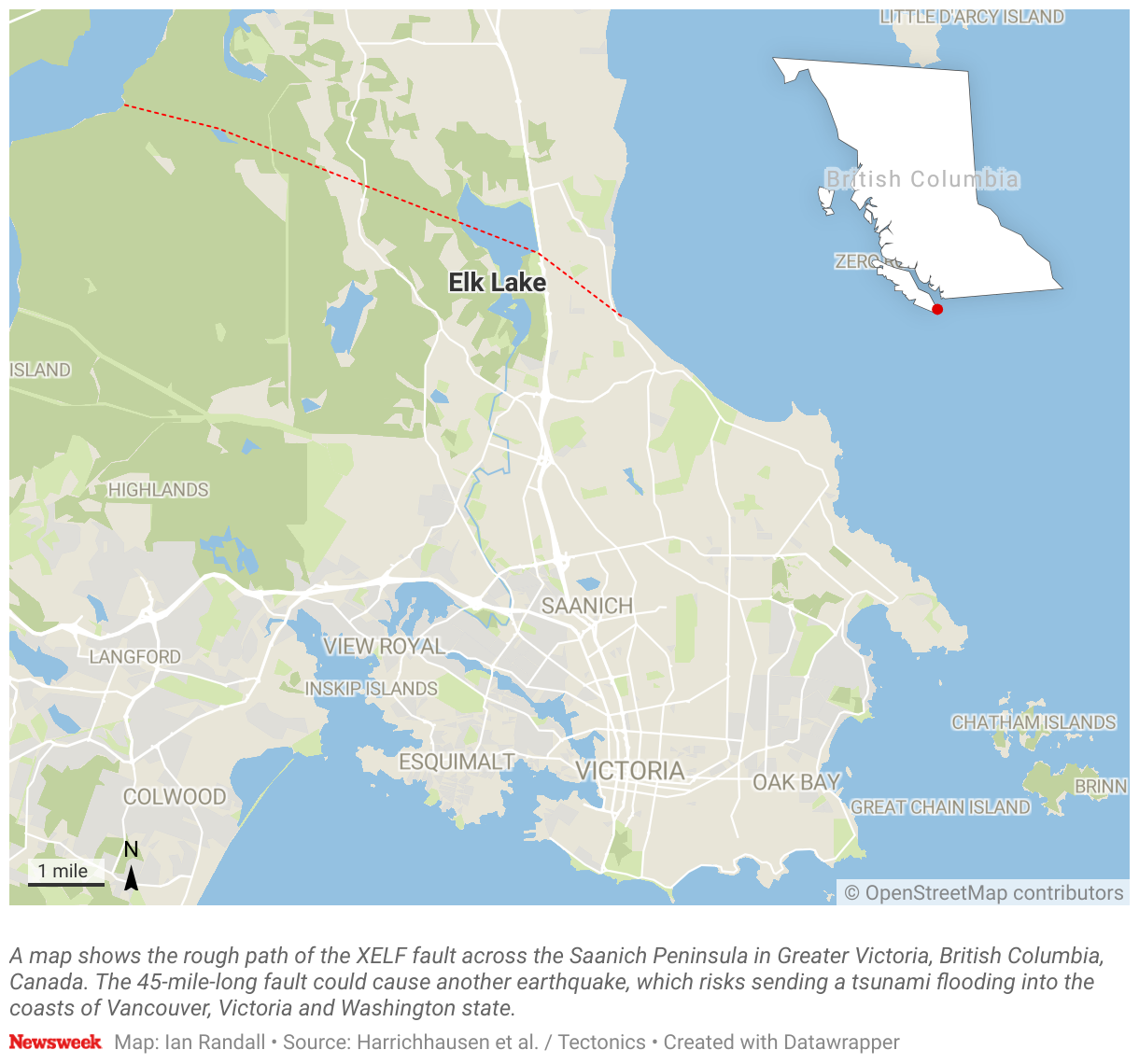
A brand new 45-mile fault line has been discovered stretching along Canada's Vancouver Island, just north of the Washington state border, and may pose a tsunami risk to people nearby.
The fault line was suspected to be lurking in the region by geologists, mineralogists and Earth and ocean scientists, who had recently found evidence of an earthquake occurring on the Saanich Peninsula between 4,700 and 2,300 years ago, according to new research in the journal Tectonics.
Proving difficult to find due to the thick forest coverage in the area, the fault line was finally found after intensive research.
"We suspected this fault was present due to an offset land surface (scarp) that we were able to see in high-resolution topography data," Nicolas Harrichhausen, a geology researcher at the Université Grenoble Alpes in France told Newsweek.
"The offset land surface is a landscape feature that formed during the last glacial maximum, so we know the offset had to occur after the glaciers retreated (after 14,000 years ago). This offset was also relatively consistent and linear for a substantial distance, suggesting it was formed by a fault plane."

If the fault were to see an earthquake, it could trigger a tsunami that would be catastrophic to those living nearby in both Canada and on the U.S. West Coast.
"This newly identified fault, the XEOLXELEK-Elk Lake fault (XELF), crosses Saanich Peninsula within Greater Victoria and poses a hazard to the region's [approximately] 400,000 inhabitants," the authors said in the paper.
The fault line was discovered after a detailed investigation involving shallow geophysical surveys, analyzing historical images, and remote sensing.
"The evidence that confirmed the active fault's presence was the exposure of faulted and folded Quaternary sediments that we exposed in the trench we excavated across the scarp. Using radiocarbon dating of organic matter in the sediment, we were able to date the offset and folded sediments, and the sediments that overlie the deformed units to estimate the timing of the earthquake that caused the folding and faulting," Harrichhausen said.
On further investigation, they found that the faultline runs northwest to southeast for around 45 miles and may be a slip-dip fault, meaning that the rocks move vertically up and down against each other rather than sliding side to side.
In the paper, the researchers suggest that an earthquake at this faultline would likely trigger a tsunami that could hit the Canadian cities of Victoria and Vancouver, as well as places as far away as Seattle, Bellingham, Olympia and Tacoma in the United States.
"If a M 6.1 to M 7.6 earthquake were to occur today, it would cause substantial damage. A similar reverse earthquake within this magnitude range was the recent M 6.8 earthquake in Morocco that caused major damage and killed almost 3000 people," Harrichhausen said. "However, predicting the exact damage requires modelling of the shaking a similar earthquake to the one we observe on the XELF. By estimating the shaking, we would have a better idea of the likely damage to infrastructure."

The last earthquake from this fault line, which occurred several thousand years ago, had a magnitude of between 6.1 and 7.6 and may have also triggered a tsunami.
"There is a high potential that a local tsunami was generated by the paleo-earthquake recorded on the XELF, either from vertical offset of the seafloor or during a shaking-induced landslide. Future analyses of the subaqueous structures, along with exploration for regional tsunami deposits, could further test this hypothesis," the authors wrote.
The researchers note that it's very hard to predict when the fault line may cause another earthquake, but further study of the fault's past will help them to elucidate how much risk it poses to people nearby.
"Determining whether it produced recent large earthquakes is important for updating regional earthquake hazard models and increasing earthquake preparedness," they said.
Do you have a tip on a science story that Newsweek should be covering? Do you have a question about fault lines? Let us know via science@newsweek.com.
Update 12/18/23, 11:54 a.m. ET: This article was updated with comment from Nicolas Harrichhausen.
Update 12/14/23, 10:57 p.m. ET: This article was updated with a map of the fault line.
Uncommon Knowledge
Newsweek is committed to challenging conventional wisdom and finding connections in the search for common ground.
Newsweek is committed to challenging conventional wisdom and finding connections in the search for common ground.
About the writer
Jess Thomson is a Newsweek Science Reporter based in London UK. Her focus is reporting on science, technology and healthcare. ... Read more
To read how Newsweek uses AI as a newsroom tool, Click here.