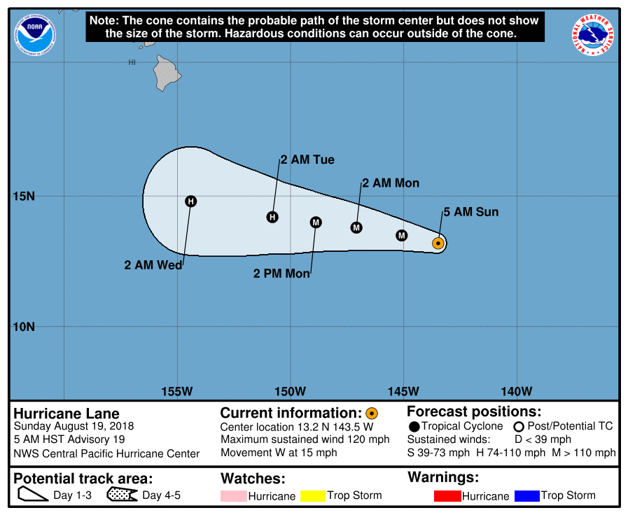
Hurricane Lane's path is forecast to run south of the main Hawaiian Islands on Wednesday and Thursday of this coming week, but the National Hurricane Center said it is still too early for interests in the state to ignore the storm.
In its Sunday forecast update, the National Hurricane Center said this morning that Hurricane Lane 2018 is currently a category 3 storm, with maximum winds sustained at 120 miles per hour. Lane is located about 890 miles east, southeast of Hilo, Hawaii, or 1,100 miles east, southeast of Honolulu, Hawaii. The NHC said Hurricane Lane may strengthen.
There are currently no coastal warnings or watches in place due to Lane, moving over open water in the Pacific, but the National Hurricane Center said Hawaii could receive some impact and that because the long-range forecast can be difficult to pin down that vigilance is advised.
"Lane is forecast to pass south of the main Hawaiian Islands Wednesday and Thursday, potentially causing local impacts as it tracks west-northwestward," The National Hurricane Center said. "Interests in these islands should watch the progress of Lane closely, since long-range track and intensity forecast errors can be large."
The National Hurricane Center notes uncertainty about how a ridge will impact the storm's movement, making Hurricane Lane's long-range forecast path, track hard to predict.
"A shift toward the west-northwest will likely begin beyond 72 hours as Lane approaches the western end of the ridge," the National Hurricane Center said in its Sunday morning discussion of the storm. "The forecast models are showing this western end of the ridge will erode due to an upper-level trough digging down northwest of the Hawaiian Islands. Due to increasing uncertainty about the strength of the ridge, the model spread has increased dramatically tonight."
The National Hurricane Center said an airplane will be sent into the storm tonight for better analysis, in hopes of sharpening the forecast and its potential threat to Hawaii Islands.
"A NOAA G-IV aircraft plans to do a synoptic sampling in the environment around the Hawaiian Islands and Lane later today," the National Hurricane Center said. "The valuable data collected during this mission will be available to better initialize the forecast models."
Uncommon Knowledge
Newsweek is committed to challenging conventional wisdom and finding connections in the search for common ground.
Newsweek is committed to challenging conventional wisdom and finding connections in the search for common ground.
About the writer
To read how Newsweek uses AI as a newsroom tool, Click here.