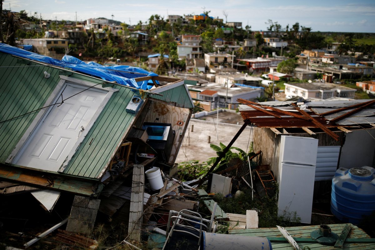
Peak storm season has hit the Atlantic. Last month, Hurricane Lane sent flash floods and mudslides coursing through Hawaii's Big Island as Maui weathered fire from broken power lines—just a hint of the destruction these powerful storms can wreak.
Hurricanes can claim thousands of lives and cause billions of dollars of damage. But we know relatively little about them, and their paths can be difficult to predict.
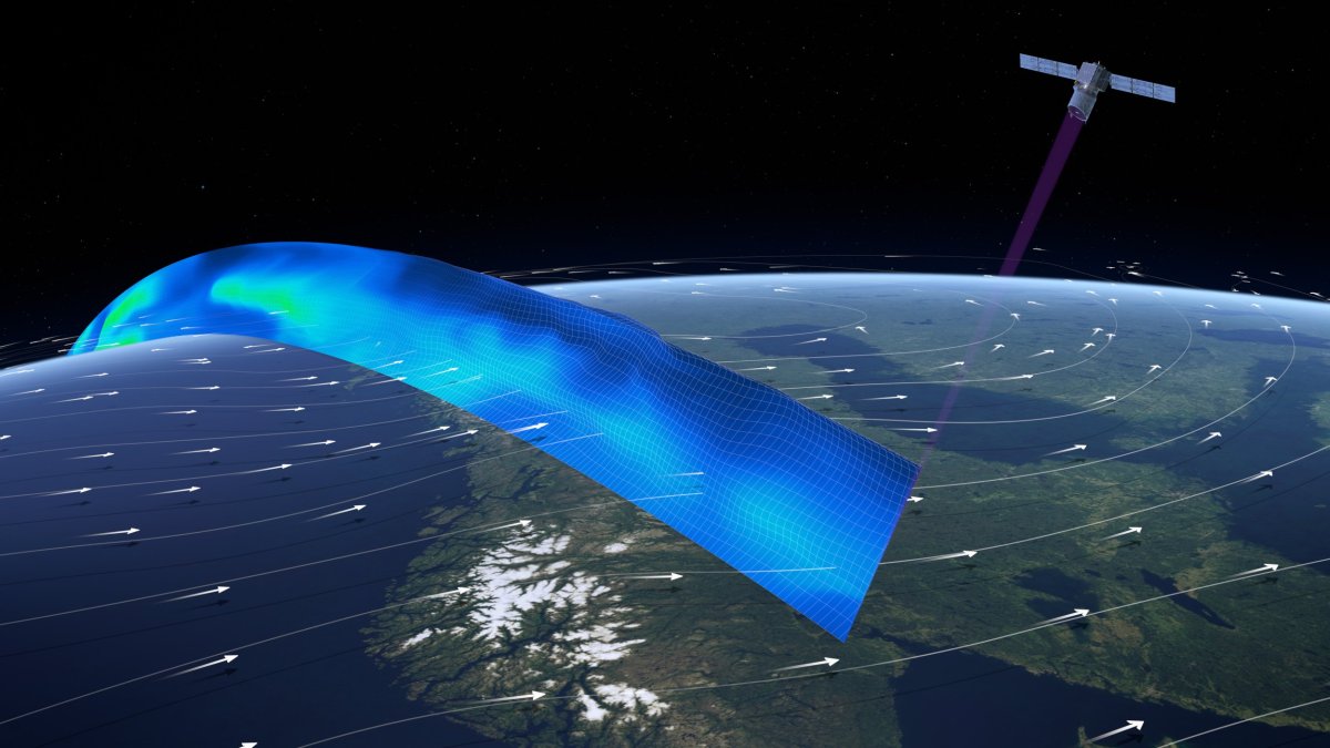
Meteorologists have high hopes for a proof-of-concept satellite recently launched by the European Space Agency. This cutting-edge machine will fire a laser through space to track the movement of particles through Earth's atmosphere. In other words, it will track wind.
Hurricanes are towering cyclones of wind and cloud that build up over warm waters in the Atlantic and eastern Pacific Oceans. As warm air rises from near the ocean surface it leaves areas of lower pressure air below. Higher pressure air flows into these regions, before it too warms and rises.
Eventually, this rising warm, moist air cools and forms clouds. Evaporating water from the surface of the ocean fuels a storm's growing column of wind and clouds, which churns round and round like a spinning top. When winds hit 74 miles per hour, a tropical storm becomes a hurricane.
As average global temperatures have warmed, hurricanes have become more intense. As this trend continues, the importance of understanding these violent cyclones grows with each passing year.
Agencies such as the Federal Emergency Management Agency (FEMA) use weather forecasts to work out how to deploy resources, supplies and personnel in advance of a hurricane, a spokesperson told Newsweek. Predictions are crucial for local authorities to organize evacuations, shelters and school closures. But this data is far from perfect.
"Hurricane warnings for a potential landfalling storm are normally disseminated to the public about 36 hours in advance," Christopher Velden of the University of Wisconsin-Madison, an expert on hurricane research and environmental satellites, told Newsweek. "Any new observations, model guidance, or science that can allow earlier warnings will be a benefit to preparation time and public safety."
To understand wind, meteorologists release hundreds of weather balloons carrying devices called "radiosondes" into the skies. Although they give scientists "a really accurate" picture of temperature, humidity and wind structures right through the atmosphere, "you just can't fly them everywhere," John Remedios, director of the U.K.'s National Centre for Earth Observation, told Newsweek.
Balloons aren't released over vast swathes of ocean—crucial areas where hurricanes build. Certain regions over the tropics, he said, are currently observed by scatterometers: microwave radar sensors that measure winds at the surface of the sea.
Some existing satellites, Velden said, estimate winds by proxy of moving clouds and moisture. They're fairly accurate, he said, but only give you a picture of winds above the cloud tops. Satellites, wind balloons and airplane lidars feed crucial data into numerical weather prediction models. But their accuracy is limited by the data we are still missing.
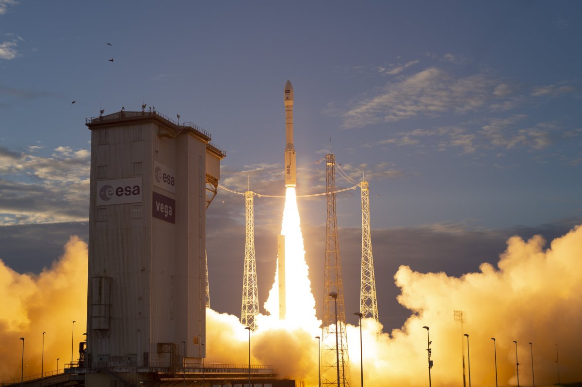
The Aeolus satellite, launched August 22 from the European Spaceport in Kourou, French Guiana, looks set to fill in some of these gaps. If successful, the experimental instrument—named for the Ancient Greek keeper of the winds—will build a picture of wind that would otherwise go unmapped.
Its laser should be able to capture the cross-section of a hurricane: A vertical profile of its twisting streams of wind. Wind profiles, Velden explained, are crucial for numerical models to build an accurate picture of the processes that drive weather.
But Aeolus isn't a magic bullet for storm prediction. In an ideal world, the satellite would be just one of a constellation that worked together to provide a more comprehensive dataset. Instead it will traverse its sun-synchronous orbit alone. Airbus's Aeolus project manager, Richard Wimmer, hopes the success of the mission will inspire more funding for future constellations.
Until it has proven its worth, it is unlikely other satellites will follow, the European Space Agency's Earth Observation Programs director, Josef Aschbacher, told Newsweek. Other agencies with similar ambitions, Ashbacher said, will be waiting on the results before they dip their own toes in the water. "At the moment everybody's waiting [to see if this satellite works]…they are waiting for Europe to succeed."
And if Aeolus works, he added, it will be no easy task to create another similar satellite. Fiercely proud of the project, he told journalists in Kourou that Aeolus is "a masterpiece of engineering." Europe has developed keen skills and specific expertise that other regions may struggle to replicate, he told Newsweek.
Development of the satellite was beset by technical problems and spiralling costs. Engineers admit they almost gave up on getting the $560 million satellite finished. In the end, it faced more than a decade of delays.
Aeolus's nominal lifetime is just three and a half years, leaving the very real prospect meteorologists will once again miss out on a vital chunk of wind data. "There will be a period again where [meteorologists] potentially lose the data," Wimmer said. But the input it provides over the course of its lifetime will improve the accuracy of weather models in the future, he added.
Aschbacher agrees. "The feeding of new data will not happen until a new generation, a new operational system, is in place. But you will still have a lasting benefit because of this better information—you can refine and better tune your weather prediction models."
Day-to-day predictions, as well as our understanding of storms and hurricanes, should see a marked improvement once Aeolus is up and running. A global view will help meteorologists track the activity in the tropics and the Atlantic ocean that will impact weather over Europe days later.
"There will always be an unpredictable element to weather forecasting," Velden said. "The weather models we employ to mimic our atmosphere's behavior will never be perfect." But Aeolus, he hopes, will be "another step in the right direction."
Uncommon Knowledge
Newsweek is committed to challenging conventional wisdom and finding connections in the search for common ground.
Newsweek is committed to challenging conventional wisdom and finding connections in the search for common ground.
About the writer
Katherine Hignett is a reporter based in London. She currently covers current affairs, health and science. Prior to joining Newsweek ... Read more
To read how Newsweek uses AI as a newsroom tool, Click here.