The recent seismic activity on Iceland's main island has "completely changed the assumptions" of experts concerning monitoring of the affected area, as officials warn that new hazards could spring up as the region is "entering a prolonged active period."
In an update on Tuesday, the Icelandic Meteorological Office said that the Reykjanes Peninsula—where an eruption was thought likely after a burst of seismic activity from November 10—would be subject to increased monitoring and more experts drafted in to help.
It has previously expressed uncertainty as to when and where an eruption may occur after a decline in the number and severity of earthquakes around a vertical dike of magma that has pushed up through a weak point in the Earth's crust—estimated to be around 9.3 miles long and running alongside the coastal fishing town of Grindavik.
The intrusion is thought to be connected and being fed by another, horizontal reservoir of magma—around 6 miles in diameter and which has been pushing the ground up by around a centimeter (nearly half an inch) a day—under Svartsengi, a nearby geothermal power plant.

On Wednesday, the Icelandic Met Office said the ground around Svartsengi "continues to inflate," meaning "further dikes or an eruption remain possible." While the area the previous dike formed is anticipated to be the most likely area of eruption, experts have not been able to discount the possibility that magma propagates elsewhere in the region.
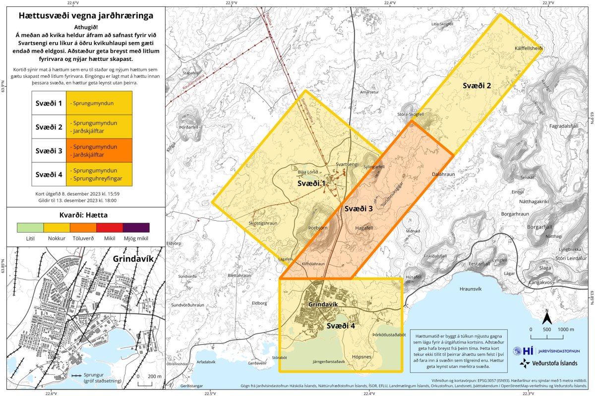
On Friday, the Icelandic Met Office produced an updated map of the hazard zones on the Reykjanes Peninsula, showing the area around the dike in orange—assessed to have the existing hazards of earthquakes and crack formations—as well as further north along the path of the dike, where an eruption is thought less likely; Svartsengi, where crustal uplift is ongoing; and Grindavik, where an eruption could impact local structures.
Between 1,500 and 1,800 earthquakes a day were being recorded from November 10 for nearly two weeks, before dropping to the low hundreds. Between 200-300 earthquakes have been registered a day in the past two days, while the Icelandic Met Office said as of 6:15 a.m. ET on Wednesday there had so far been a hundred.
While the intense seismic activity around the vertical dike appears to have subsided for the time being, the continued flow of lava into the horizontal intrusion means another could form, or more magma flow into the dike, without warning.
In recent weeks, authorities in Iceland have built earth walls, along with conduits and canals, around Grindavik and Svartsengi, in a bid to direct lava away from buildings in the event of an eruption. Grindavik's population of nearly 4,000 were also evacuated after cracks appeared in the ground.
On Tuesday, officials met with residents of Grindavik to tell them that there remained "a chance of another magma flow and also an eruption."
"The Icelandic Meteorological Agency's role with monitoring and risk assessment is to create conditions for emergency responders to make decisions about actions," Árni Snorrason, director-general of the Icelandic Met Office, said. "There are numerous other factors that emergency responders need to look at and evaluate when deciding when and how the Grindvíkings can return home."
A sudden shift in the North American tectonic plate away from the Eurasian plate is thought to have allowed magma to suddenly push upwards through a rift that runs between the two of them under Iceland.
One Icelandic volcanologist previously told Newsweek that while the volcanic episode that began on November 10 may have ended, it may mark the start of an "intense" period of tectonic activity based on historic trends.
"We know that this is not the end of activity on the Reykjanes peninsula," Haraldur Sigurdsson, emeritus professor of geophysics at the University of Rhode Island, said, noting that much of Iceland's infrastructure—including the capital, Reykjavík—was located in the region.
Correction 12/14/23 6:00 a.m. ET: This story has been amended due to a translation error.
Uncommon Knowledge
Newsweek is committed to challenging conventional wisdom and finding connections in the search for common ground.
Newsweek is committed to challenging conventional wisdom and finding connections in the search for common ground.
About the writer
Aleks Phillips is a Newsweek U.S. News Reporter based in London. His focus is on U.S. politics and the environment. ... Read more