A new map shows that parts of Georgia could be swallowed by the ocean if sea levels continue to rise, as experts warn coastal states will suffer some of the worst effects of climate change.
Beach towns could face a watery future within the span of a lifetime, amid warnings that sea levels could jump dramatically by the year 2100, altering the shape of American shorelines. The National Oceanic and Atmospheric Administration (NOAA) has created an interactive map showing how the country's coastline would change under various sea level rises.
Sea levels are predicted to rise as ice sheets, particularly around the poles, continue to melt. Antarctica alone contains enough frozen water that it would raise sea levels by an astronomical 190 feet if it were to all melt, according to scientists analyzing the trend. However, a complete loss of ice sheets could take thousands of years to occur and ice sheet loss is notoriously difficult to predict. For example, there could be a sudden collapse that displaces a huge amount of water into the ocean almost instantly as the ice breaks up and melts.
The United Nations' Intergovernmental Panel on Climate Change (IPCC) estimates there is likely to be up to 1.10 meters (3.6 feet) of sea level rise by the year 2100 if global greenhouse gas emissions are not mitigated, but said a sea level increase "of 2 or more meters [almost 6.6 feet] cannot be ruled out."
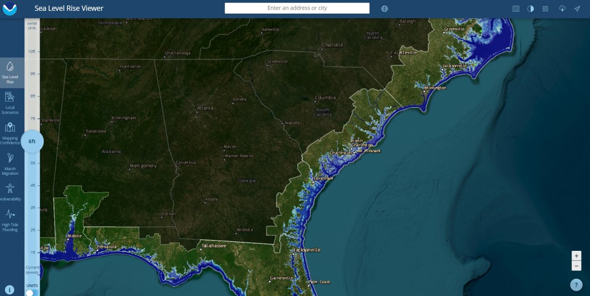
NOAA's interactive map, available on its website, shows how the U.S. looks at present, with current sea levels for the Mean Higher High Water (MHHW) level which is the average level of the highest tide each day observed over a 19-year period.
But the map's tools show how Georgia would be hit if sea levels were to rise by various levels, ranging from 1 foot to 10 feet. Areas of new ocean are denoted in light blue. And moving the sea 6 feet higher, as has been touted as possible for 2100, shows how the state would change as a result.
Much of the coastal counties of Camden, Glynn, McIntosh, Liberty, and Bryan are dramatically submerged. Glynn County, which was home to more than 84,000 people in 2020 according to that year's census, will even lose neighborhoods around the county seat of Brunswick.

The city of Savannah looks set to lose part of its river shoreline, while parts as far inland as Chatham County are shaded to show they would be underwater.
Zooming in further reveals patches of green, that indicate regions likely to suffer regular flooding, with areas around Black Creek and Little Hearst Branch stream, as well as the Port of Savannah-Garden City set to be affected. And the Savannah Convention Center would be located underwater, the map suggests, while across the Savannah River the rising waters would have claimed the World War II monument.
Previous analysis by National Geographic in 2013 suggested that while a significant chunk of the Atlantic and Gulf Coasts would disappear underwater, including parts of New York, and the entirety of Florida if all the world's ice sheets melted, the West Coast would be hit too.

Even under less extreme scenarios, rising sea levels would see San Francisco's hills become islands, while the Central Valley would become a new, large bay. Large portions of Los Angeles and San Diego would also vanish, while the Gulf of California would approach the Joshua Tree National Park.
David Thornalley, a professor of ocean and climate science at University College London, warned that 2100 was only a single lifespan away, telling Newsweek that significant sea rises "would happen if we didn't take steps to reduce our GHG (greenhouse gas) emissions."
But he warned the longer-term effects are likely to be even more dramatic. "In the long term, even under more moderate emission scenarios, sea level rise after a few hundred years is expected to be in excess of 10 meters [33 feet]," he said.
Newsweek has reached out to NOAA by email seeking further information and comment about its map and stark predictions for the future.

Correction on 04/12/24 at 10.31 ET. Corrects headline to could
Uncommon Knowledge
Newsweek is committed to challenging conventional wisdom and finding connections in the search for common ground.
Newsweek is committed to challenging conventional wisdom and finding connections in the search for common ground.
About the writer
Get in touch with Chloe Mayer by emailing c.mayer@newsweek.com
To read how Newsweek uses AI as a newsroom tool, Click here.