The National Weather Service (NWS) shared a map on Monday that showed which states could expect a significant late winter storm over the weekend and into next week.
The last few weeks have brought a range of unexpected weather across the United States, from abnormally warm temperatures in late February in the Midwest to a "biblical" blizzard in California that dumped as much as 10 feet of snow in some mountain regions.
Last week, a strong winter storm covered much of Colorado and plunged temperatures on the West Coast by more than 25 degrees. Now, four states in the Northern Plains are facing an increased likelihood of a significant late winter storm.
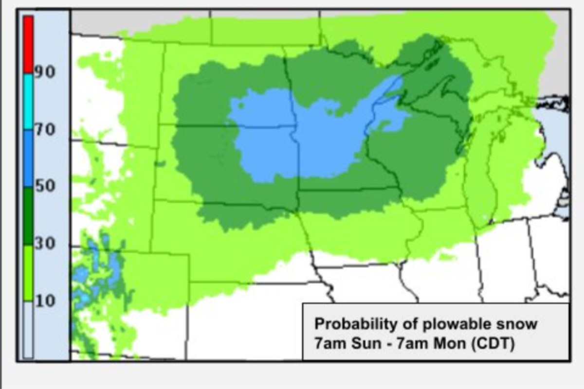
North Dakota, South Dakota, Minnesota and Wisconsin have a 50 percent to 70 percent chance of receiving heavy snowfall from Saturday to next Tuesday, according to the map. Nebraska and Iowa were included in the states with a 30 percent to 50 percent chance of heavy snow. Montana, Wyoming, Kansas, Colorado, Illinois and a small northwestern corner of Indiana has a 10 percent to 30 percent chance for heavy snow.
"Confidence is beginning to increase that a significant winter storm will impact portions of the Northern Plains and Upper Midwest this weekend into early next week," the NWS Weather Prediction Center posted on X, formerly Twitter, on Monday night. "Stay tuned for forecast changes and details in the next few days!"
Confidence is beginning to increase that a significant winter storm will impact portions of the Northern Plains and Upper Midwest this weekend into early next week. Stay tuned for forecast changes and details in the next few days! pic.twitter.com/LAQnVrH6gn
— NWS Weather Prediction Center (@NWSWPC) March 18, 2024
The exact timing and track of the storm is uncertain, the NWS Weather Prediction Center said, as are snowfall amounts and which areas could receive rain. The center also is unclear about what travel impact may be caused by the storm.
NWS meteorologist Zachary Hargrove said being four to six days out from the storm makes it difficult to predict.
"When you're that far out, there's a lot of different model solutions, and trying to pick out the best scenario can be somewhat of a challenge, especially since that storm is not even on land in the U.S. at this point," Hargrove told Newsweek.
As the storm progresses, predicting its path will become easier, Hargrove said.
However, NWS Bismarck said that there is potential for at least 6 inches of snow.
"Confidence has increased slightly for the potential of winter impacts across North Dakota this weekend. The potential for accumulations of at least 6 inches is medium, with low to medium confidence in amounts higher [than] a foot," the office posted on X on Monday.
Confidence has increased slightly for the potential of winter impacts across North Dakota this weekend. The potential for accumulations of at least 6 inches is medium, with low to medium confidence in amounts higher that a foot. #ndwx pic.twitter.com/HGfDSoI2CA
— NWS Bismarck (@NWSBismarck) March 18, 2024
The storm would come after another system that is threatening at least 2 inches of snow across the area on Wednesday and Thursday.
Uncommon Knowledge
Newsweek is committed to challenging conventional wisdom and finding connections in the search for common ground.
Newsweek is committed to challenging conventional wisdom and finding connections in the search for common ground.
About the writer
Anna Skinner is a Newsweek senior reporter based in Indianapolis. Her focus is reporting on the climate, environment and weather ... Read more
To read how Newsweek uses AI as a newsroom tool, Click here.