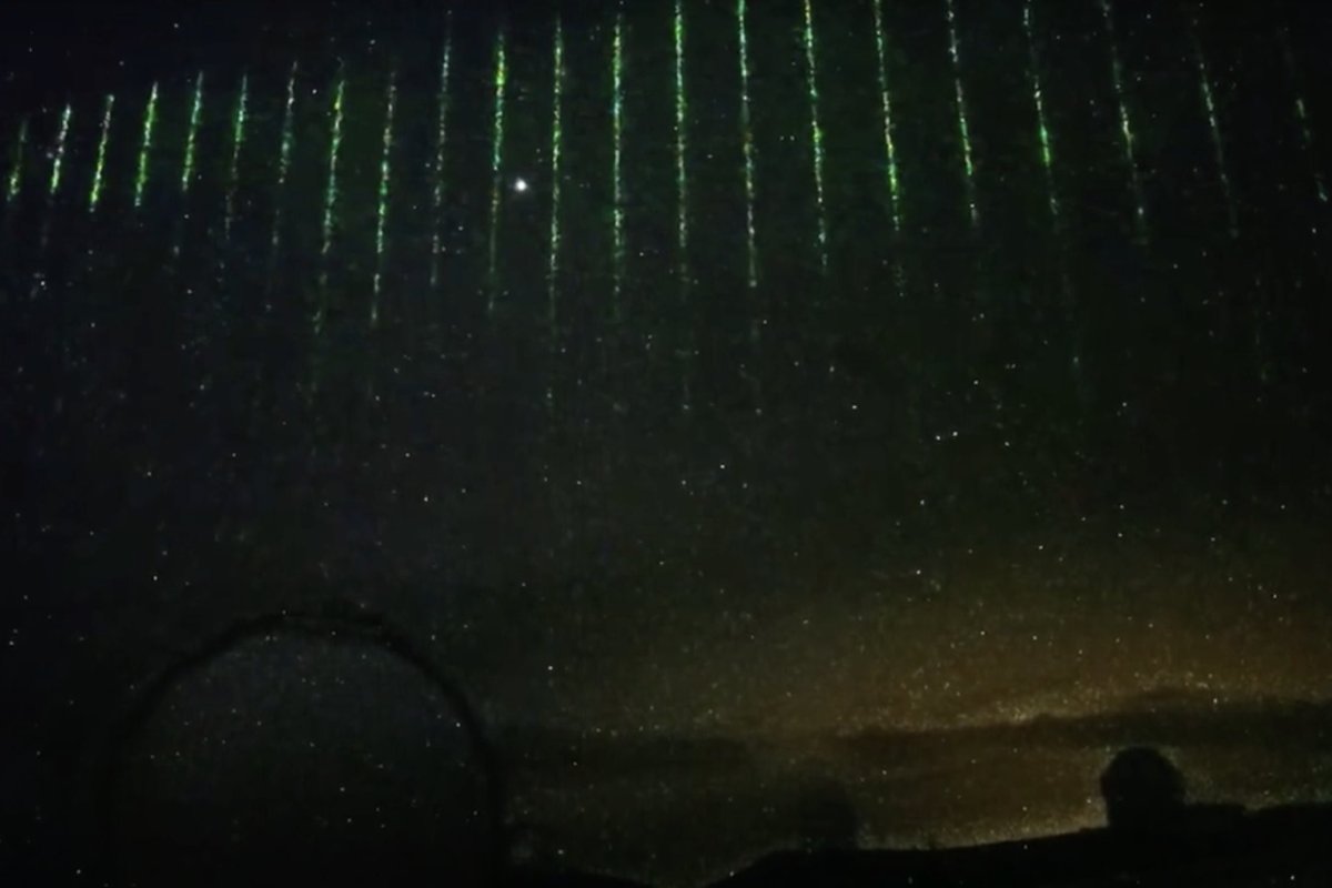
On January 28—the same day a suspected Chinese spy balloon was detected by the U.S. off the coast of Alaska—a camera watching the night atop a mountain in Hawaii caught a series of green laser beams darting across the sky.
Lasting a matter of seconds, just as it turned 2:00 a.m. local time (7:00 a.m. ET), footage from the camera caught the bands arcing left to right, footage shows. While the owners of the camera initially supposed it was a NASA mapping satellite, the U.S. space organization has said that it was not them, suggesting it may have been the Chinese.
The camera—looking out from Mauna Kea, a dormant volcano—is attached to the Subaru Telescope, and is a joint venture between the Asahi Shimbun newspaper and the National Astronomical Observatory of Japan (NAOJ).
On January 29, it posted the footage on YouTube, suggesting that the beams could have come from a remote-sensing laser altimeter from NASA's ICESat-2/43613 satellite, launched in September 2018 as part of its Earth Observing System with the goal of measuring and monitoring the impacts of climate change. According to NASA, it is able to emit 10,000 pulses a second.
However, on February 6, the description of the video was updated with a new explanation for the curtain of light beams over Hawaii.
Citing Anthony Martino, a deputy project scientist working on the ICESat-2 mission, the NAOJ note said the lights were "not by their instrument but by others."
"His colleagues, Dr. Alvaro Ivanoff et al., did a simulation of the trajectory of satellites that have a similar instrument and found a most likely candidate as the ACDL instrument by the Chinese Daqi-1/AEMS satellite," it added. "We really appreciate their efforts in the identification of the light."
"At the time of the sighting by the sky camera at Mauna Kea, Daqi-1 was on a roughly north-south path that took it over the eastern half of Hawaii Island, about midway between Mauna Kea and the eastern tip of the island," Martino told Newsweek. "At the same time, ICESat-2 was just off the west coast of Africa."
"Less than an hour earlier, at 11:12 UTC (6:12 a.m. ET), ICESat-2 passed west of Hawaii Island on a roughly north-south path, crossing the eastern tip of Maui. The camera at the Subaru Observatory was pointed toward the east, in the direction to see Daqi-1 but not ICESat-2 on this occasion," he added.
According to Orbital Focus, a satellite orbit monitoring service, at 2:00 a.m. local time the Daqi-1 satellite was likely passing overhead and was the "probable culprit" and was on a north to south trajectory that "fits the left-right motion of the video."
Martino explained that both were in near-polar orbits; ICESat-2 goes from 88 degrees north to 88 degrees south in latitude in around 90 minutes, while Daqi-1 goes from 82 degrees north to 82 degrees south.
Fears have been raised of Chinese spying on the U.S. after the suspected surveillance balloon was spotted in U.S. airspace. Defense officials allowed the balloon to pass across Canada and continental America, before it was shot down off the coast of South Carolina on February 4 on the orders of President Joe Biden.
China has maintained that the balloon was a civilian weather balloon that had been blown off course, and expressed outrage at it being shot down.
The Daqi-1 satellite's stated use is for atmospheric environmental monitoring, like the ICESat-2. It was developed by the Shanghai Academy of Spaceflight Technology of the China Aerospace Science and Technology Corporation (CASC), a state-owned enterprise firm, the company said, and is designed to monitor pollutants and greenhouse gases.
It was launched by China in April 2022. Newsweek was unable to contact CASC for comment.
Martino said both satellites contained lidar instruments, which work like radar but with lasers to detect the topography of the ground below them, as well as clouds or aerosols suspended in the atmosphere. ICESat-2's primary objective is measuring the change in the levels of ice sheets and the thickness of ice in the ocean.
"For many of these scientific objectives, including atmospheric models, global coverage is very important," he added.
Martino noted that the satellites fly over a different longitude on each orbit, and so over many orbits, "the satellite will come within a certain distance of every point on Earth between the extreme latitudes."
Update 02/13/23, 3:10 a.m. ET: This article was updated to include comment from Anthony Martino, a deputy project scientist working on the ICESat-2 mission at NASA.
Uncommon Knowledge
Newsweek is committed to challenging conventional wisdom and finding connections in the search for common ground.
Newsweek is committed to challenging conventional wisdom and finding connections in the search for common ground.
About the writer
Aleks Phillips is a Newsweek U.S. News Reporter based in London. His focus is on U.S. politics and the environment. ... Read more