A map showing how the ground around the Yellowstone supervolcano has deformed over the last two years has been released by the U.S. Geological Survey.
The map, by USGS geophysicist Chuck Wicks, shows movement around the caldera between 2015 and 2017 using radar images of Earth's surface collected from orbiting satellites.
In this time, the ground around the Norris Geyser Basin rose by just under 3 inches, while there was a downdropping of the earth within the Yellowstone caldera. In the map, the rings of color show where the ground's elevation has changed.
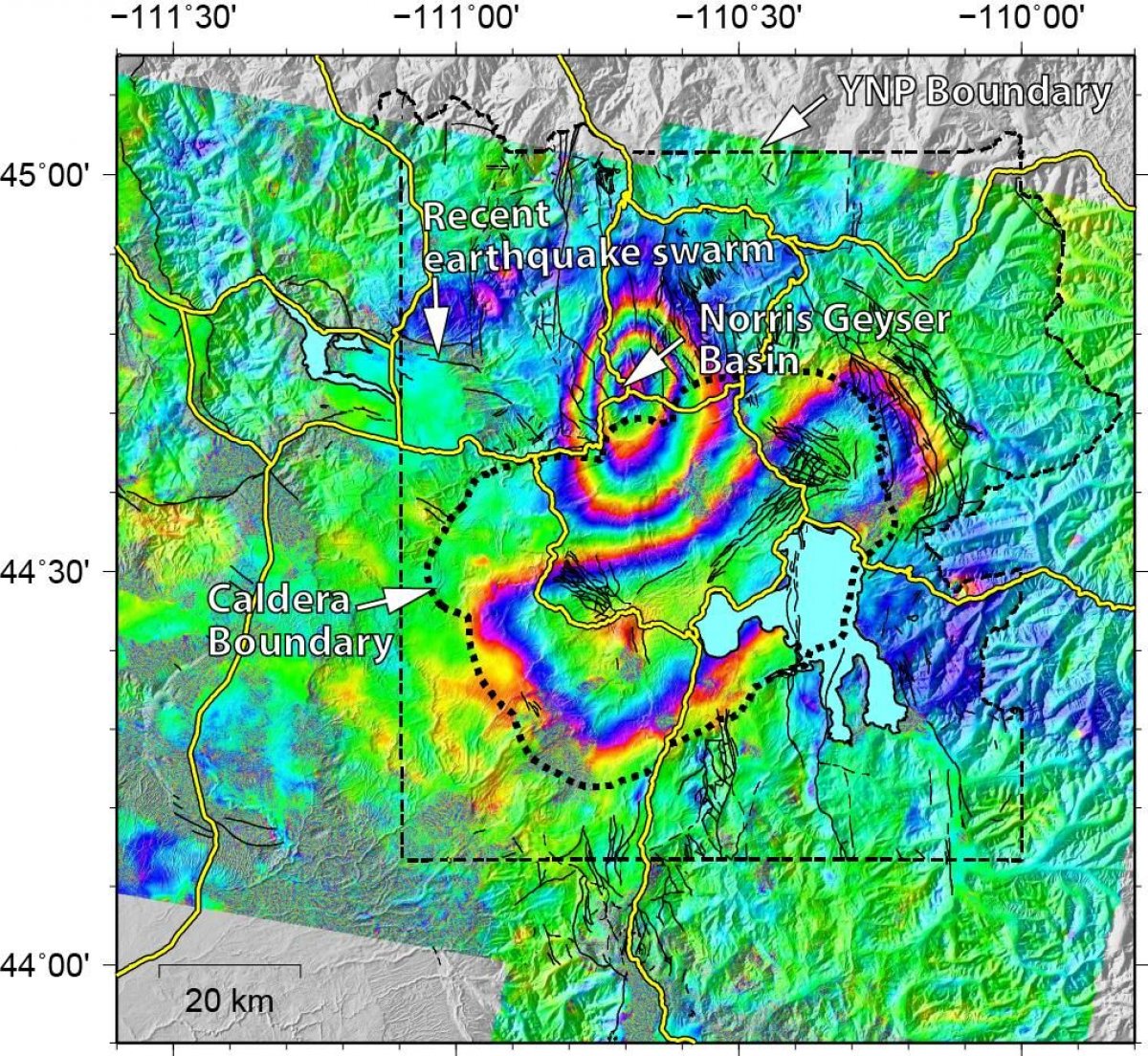
"The uplift and subsidence is usually interpreted as due to addition or withdrawal of deep magma and related gases and water at depths five to 15 km [3 to 9 miles] beneath the ground surface," the USGS said. "This cycle of uplift and subsidence is common and seems tied to earthquake swarms; that is, swarms appear to release the pressure that caused the initial uplift…thus allowing the region to return to a period of subsidence."
The recent earthquake swarm at Yellowstone, which has been ongoing since June 12, is also mapped, showing it is taking place around 12 to 18 miles from the location of the Norris uplift. As of August 3, 1,562 earthquakes had taken place, with the largest being a magnitude 4.4.
Earthquake swarms regularly occur at Yellowstone. In an interview with Newsweek in June, Jamie Farrell, a research professor at the University of Utah, which monitors volcanic activity at the site, said: "On average, Yellowstone sees around 1,500-2,000 earthquakes per year. Of those, 40 to 50 percent occur as part of earthquake swarms. This swarm is larger than the average swarm we record, but this is a normal thing to happen in Yellowstone (and other volcanic regions throughout the world)."
Understanding the ground deformation around volcanoes is important for getting an idea of what is happening beneath them. Major changes to the ground surface over time, such as swelling, sinking or cracking, can provide a warning that the volcano's behavior is changing, potentially indicating it is about to erupt.
Changes to Yellowstone's surface are normal, and the current map does not indicate anything unusual is happening.
Wicks made the latest map by comparing data from 2015 with that taken in 2017. He used a technique called InSAR (Interferometric Synthetic Aperture Radar), which uses radar waves rather than visible or infrared light. This allows researchers to track ground deformation when there is cloud cover or at night, meaning the picture produced is an accurate representation of the changes that have taken place.
Uncommon Knowledge
Newsweek is committed to challenging conventional wisdom and finding connections in the search for common ground.
Newsweek is committed to challenging conventional wisdom and finding connections in the search for common ground.
About the writer
Hannah Osborne is Nesweek's Science Editor, based in London, UK. Hannah joined Newsweek in 2017 from IBTimes UK. She is ... Read more
To read how Newsweek uses AI as a newsroom tool, Click here.