A new series of maps produced by Newsweek show how the Gaza Strip compares in size to some of the world's major capital cities, often stretching farther than many metropolises' borders in length, but dwarfed by their populations and urban sprawl.
The Gaza Strip is one of the most densely populated regions in the world, with an estimated 2.2 million people in an area measuring just 141 square miles in total, meaning buildings in its urban areas are tightly grouped together.
By that U.N. population approximation, there are on average around 15,600 people in every square mile of the territory. Compared to many sprawling cities elsewhere in the world which have expanded organically over time, the area it occupies is relatively minute.
The Israeli government claims an area of 8,630 square miles, including the contested Golan Heights region claimed by Syria. It has an estimated population of 9.1 million, with a density of around 1,135 people on average per square mile, owing to the nation's rural and desert regions, according to census statistics.
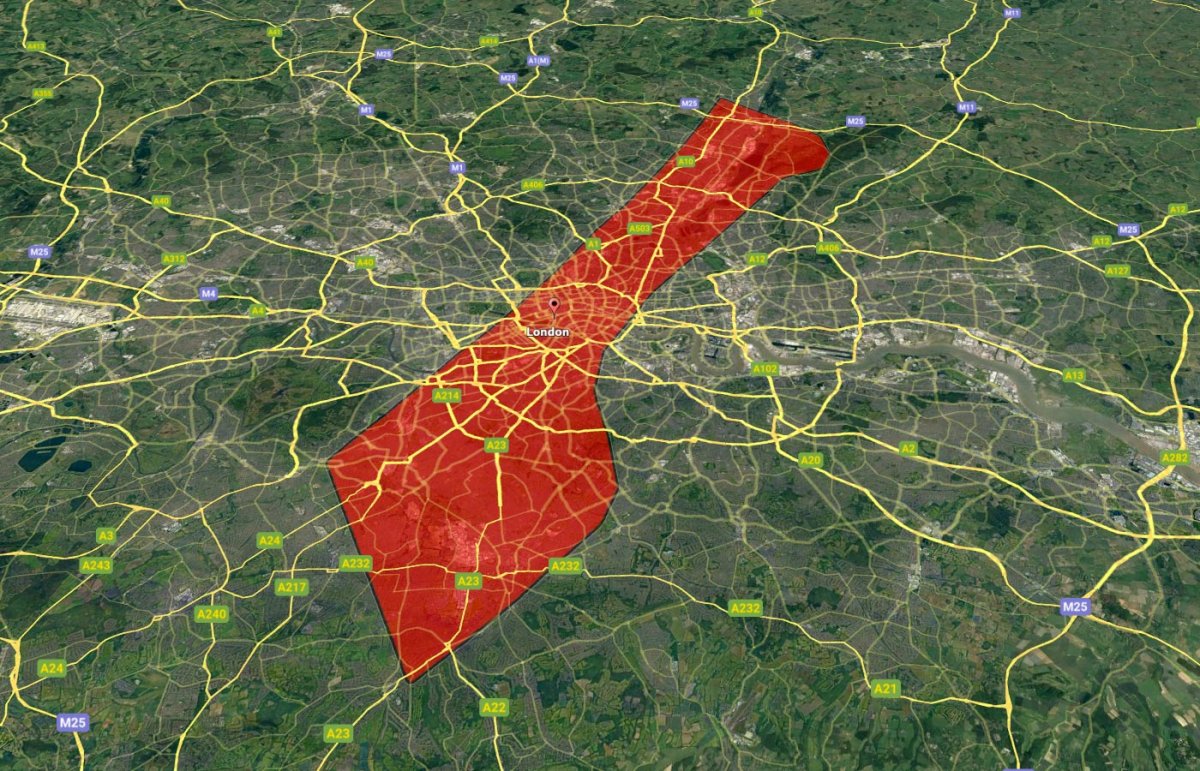
When Gaza's footprint is overlaid onto London, northeast to southwest, it covers an area from Waltham Cross, a town in Hertfordshire on the border with London, to Epsom, a satellite town in Surrey.
London, in the U.K., has a population over four times that of Gaza, and for much of its existence since being founded as a Roman settlement nearly two millennia ago has slowly sprawled outwards, subsuming many of the towns around it. In 1963, the last time its boundaries were formally fixed, its expansion led to the demise of the nearby county of Middlesex.
Given this history and London's modern economic makeup, many tend to live just outside the city center and commute into its relatively small, historic heart for work, where relatively few people live. By contrast, U.N. figures suggest Gaza has a largely even population distribution across the territory, with higher densities in its cities.
If Gaza's footprint were laid across London east to west, it would stretch from Heathrow Airport—the city's largest—to Dagenham, a historically working class, industrial area, and would cover a large swathe of London's population.
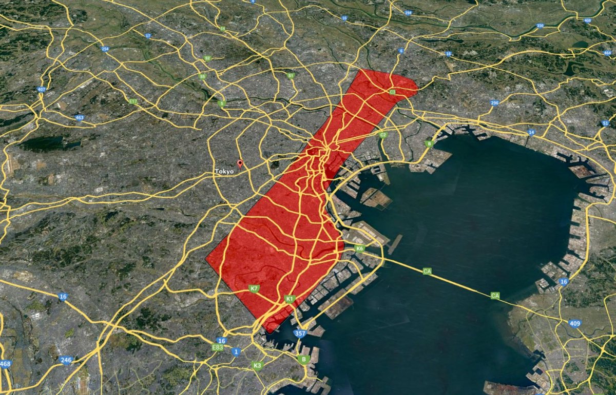
When placed over central Tokyo, in Japan, among the most populated metropolises globally, Gaza's length stretches from the Ota City area in the south across the bay and city center to Katsushika City in the north.
The Japanese capital, which emerged in the 12th century as Edo, has a population roughly six times that of Gaza and an average population density of 16,480 people per square mile—around 800 more people per square mile than Gaza.
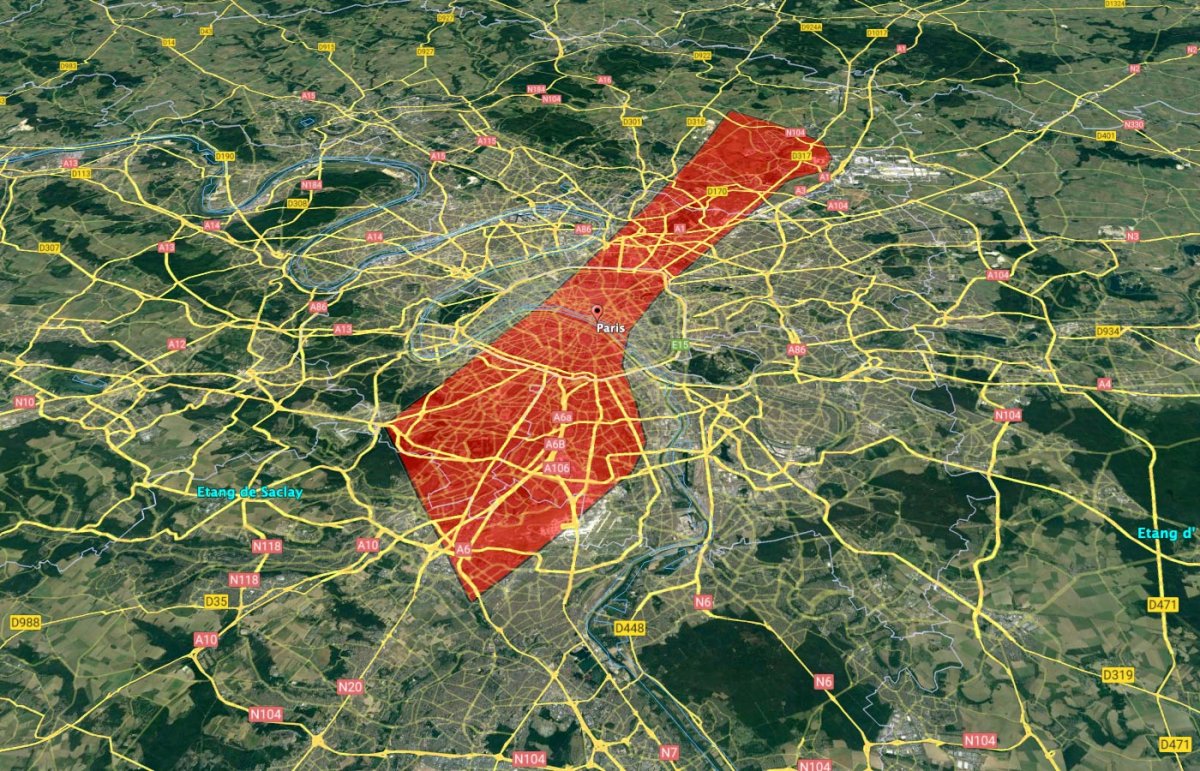
When compared to Paris, Gaza geographically spreads far beyond the official bounds of the city, stretching from Massy, a commune in the south-western suburbs outside the capital to Charles de Gaulle Airport in the northeast.
Akin to London, Paris proper occupies an area of 20 arrondissements, or boroughs, with a population of around 2.1 million—about 100,000 less than the whole of Gaza—but it's surrounded by satellite towns and suburbs that bring its metropolitan population to over 13 million.
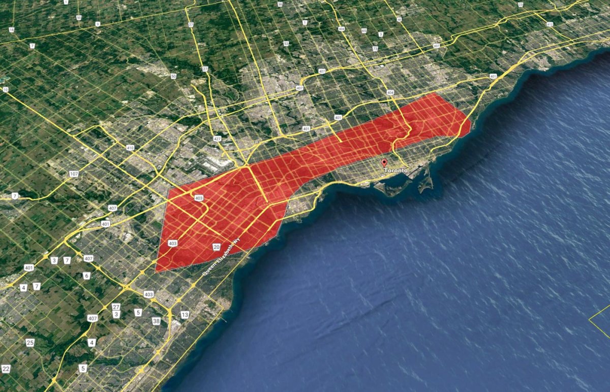
When the Palestinian exclave's footprint is overlaid onto Toronto in Canada, its southern portion, including the city of Rafah, would cover most of the adjoining city of Mississauga, while its northern part stretches over East York.
While the city of Toronto has a total population similar to that of Gaza, its metropolitan area includes over 6.2 million people. Despite this, it has an average population density far lower than Gaza—around 11,500 people per square mile.
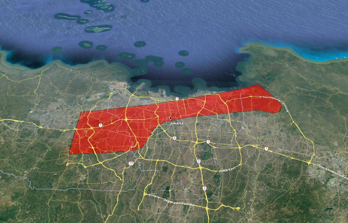
By contrast, Jakarta, the capital of Indonesia, is among the most densely populated cities in the world, with nearly 42,000 people per square mile on average from a population of around 10.7 million—just under three times the number of people per square mile of Gaza.
When the Palestinian territory's footprint is laid east to west over the city, it ranges from Tangerang, a satellite city near Soekarno-Hatta Airport, to West Java.
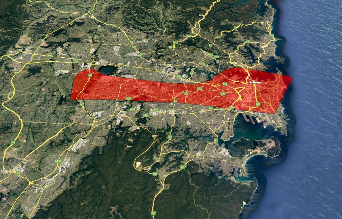
The area of Gaza occupied by the cities of Rafah and Khan Yunis would cover the region of Sydney, in Australia, south of the Parramatta River, including Bondi, Haymarket and Marrickville, and would border Sydney Kingsford Smith Airport. Its northern tip would reach over the Western Sydney Parklands.
With a total population of around 5.3 million, the capital of New South Wales and the most populous in Australia has an average population density less than 10 percent of that of Gaza's.
As experts have already suggested, Gaza's density makes an anticipated Israeli invasion of the region and the worsening humanitarian situation already occurring there uniquely challenging for the Israel Defense Forces (IDF) and aid organizations.
After Israel suffered its deadliest attack in decades at the hands of Hamas and Islamic Jihad militants on October 7, it has conducted an intensive campaign of airstrikes on Gaza.
As of Tuesday, the Gaza Health Ministry said 2,778 Palestinians have been killed and 9,700 wounded, according to the Associated Press, while Israel says over 1,400 Israelis have been killed, and at least 199 others, including children, have been taken hostage.
However, Israel has suggested it's preparing a much larger offensive on the region. With units massing on the border with Gaza, on Saturday the IDF said it was "currently preparing to implement a wide range of operational offensive plans," including coordinated strikes by air, sea and land.
"We have only started striking Hamas," Israeli Prime Minister Benjamin Netanyahu said in a televised address. "What we will do to our enemies in the coming days will reverberate with them for generations."
Analysts have said that any potential ground incursion by the IDF could pit them against well-entrenched and well-prepared Hamas fighters in a compact setting, and could risk a high number of civilian casualties owing to Gaza's densely-packed urban areas.
Despite concerns of a power vacuum in Gaza—which has been governed by Hamas since 2006—due to the removal of the Palestinian organization by force, a former Israeli ambassador to the U.N. and a member of Netanyahu's ruling party told Newsweek on Wednesday it has "no intention to hold Gaza" permanently.
Uncommon Knowledge
Newsweek is committed to challenging conventional wisdom and finding connections in the search for common ground.
Newsweek is committed to challenging conventional wisdom and finding connections in the search for common ground.
About the writer
Aleks Phillips is a Newsweek U.S. News Reporter based in London. His focus is on U.S. politics and the environment. ... Read more
To read how Newsweek uses AI as a newsroom tool, Click here.