Eight states in the western U.S. and the Pacific Northwest are bracing for a late-season winter storm anticipated to deliver a "one-two punch" as another storm follows in its wake.
The western United States, particularly California, has faced an abnormally wet winter as moisture-laden storms and atmospheric rivers dumped a deluge of rain on the region beginning in January. Many California cities have already surpassed their average annual rainfall, but an AccuWeather report anticipates that the incoming storms—expected to hit mid-week and at the end of the week, respectively—will be the last of the winter season for the southern part of the state.
The storm will arrive on Wednesday, only days after another storm left California in a sodden state once again. The incoming storm will impact California, Oregon, Washington, Idaho, Montana, Wyoming, Utah and Nevada.
"After a brief break Monday and Tuesday across the I-5 corridor with nothing more than a few showers, a more substantial storm will bring heavier, widespread rainfall to the Pacific Northwest Wednesday," AccuWeather Senior Meteorologist Dan Pydynowski said in the report.
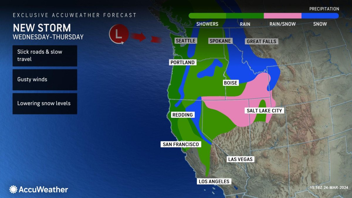
A map shared by AccuWeather shows that Oregon, Washington and California are expecting nearly all rain from the storm, with some snow falling in higher elevations. Despite the onslaught of wet weather for the Golden State, Oregon and Washington are both only 40 percent of normal for their average rainfall amounts for March.
Idaho will receive a mix of snow and rain, western Montana and western Wyoming will receive snow, and northern Utah and northern Nevada will receive a mix of snow and rain.
"A general half to 1 inch of rainfall could slow travel up and down the I-5 corridor at midweek," Pydynowski said. "This storm will also lower snow levels to around 3,500 or 4,000 feet, which could be low enough to impact some passes, including travel on Highway 2 through Stevens Pass."
Another storm is expected to hit the Sierra Nevada mountains by the end of the week, creating the "one-two punch" meteorologists warned about.
"The Sierra can have a one-two punch, with another storm expected to follow between March 29-30 that is expected to track farther south with lower snow levels," AccuWeather Lead Long-Range Meteorologist Paul Pastelok said in the report.
The storm that's expected to hit by the end of the week will be one of the last storms of the winter season to bring "widespread rainfall" to southern California, Pydynowski said.
However, more rain could be on the way for central and northern California next week, Pastelok told Newsweek.
Several cities in the region are expected to receive over an inch of rain from the storm, including Los Angeles and Pasadena.
Uncommon Knowledge
Newsweek is committed to challenging conventional wisdom and finding connections in the search for common ground.
Newsweek is committed to challenging conventional wisdom and finding connections in the search for common ground.
About the writer
Anna Skinner is a Newsweek senior reporter based in Indianapolis. Her focus is reporting on the climate, environment and weather ... Read more
To read how Newsweek uses AI as a newsroom tool, Click here.